Localization on known points from total station
Good morning everyone, I am writing to you because I would like information on how to use localization on points detected by the total station. The guide and videos found around aren't much help to me, so I'm asking you.
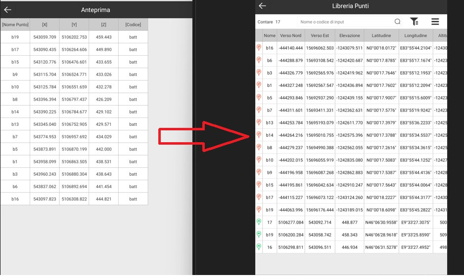
I attach an image of the first problem.
when I import the points detected on the total station the preview (left part of the photo) is correct but then... once loaded everything gets messed up (right part of the photo). The last green icons at the bottom are the ones I inserted by hand and they are correct.
I would like to understand where I go wrong during the import phase.
Once the points have been loaded I should use the "locate" command for all the points I want to involve and then click on "calculate".
If there is any holy soul who can help me I would be grateful. I would need to understand the procedure from start to finish to get a calibration done on site.
Thank you all.

Michele Negri
24 Dec, 2024

Michele Negri
07 Jan, 2025
Good morning and happy new year everyone. And let's hope it's really good in all aspects. I'm here again and... I haven't found the solution to my problem. To date I am unable to load points of a local system not based on WGS/UTM coordinates. In the file posted previously I solved the problem by correctly setting the UTM reference system with its time zone. But now I would like to understand how to load and use the localization of points not attached to any global reference system... except the local one. Can anyone help me understand if it's possible and how to do it? Thank you.

Vitaly Admin
09 Jan, 2025
Hello, Michele! To assist you better, could you please clarify a few questions: What is the brand and model of the total station you are using? Which version of SurPad are you using? Please provide the full build version. Have you checked the manual available on our website for possible answers (https://surpadapp.com/app/SurPad-4.2-Software-User-Guide-(for-Android)-V1.1-ENG.pdf)? Thank you!

Michele Negri
12 Jan, 2025
I'm using a Gnss e300pro. I tried reading the guide but it doesn't go into depth on the topic properly. the make of the total station is irrelevant because the coordinates...are coordinates. I'm using the latest version of Surpad purchased about 1 month ago.

Vitaly Admin
21 Jan, 2025

Vitaly Admin
21 Jan, 2025
1. Your total station coordinates must be for a certain coordinate system. I don't think there is such a thing as coordinates that do not belong to any coordinate system. If you mean the local coordinate system, then in the Surpad-"Project"-"Coordinate System" interface, you can define the system you need (by changing the ellipsoid, projection and other parameters).

Vitaly Admin
21 Jan, 2025

Vitaly Admin
21 Jan, 2025
3. For the display of PDOP and VDOP, you can click the "Satellite" icon on the homepage, and you can see the real-time PDOP and VDOP of the receiver in the "Position Information".

Michele Negri
26 Jan, 2025
Good morning, we didn't understand each other. The coordinates are local born from polygonal and no or no Gnss reference. Obviously I can connect them to the Wgs by detecting them on site. Practically perform a real but not virtual calibration of the antenna. My perplexity remains on the fact that if I load local coordinates I necessarily want to associate them with geographical coordinates (as per the attached image). what I would like is to load local coordinates (which can also be negative) but to which surpad does not associate geographical coordinates. Which, as mentioned before, must be detected on site or inserted manually.

Michele Negri
26 Jan, 2025
2. when I switch to the calibration function the epoch counting starts automatically. Although I'm taking direction on the point. I would like to have the start/stop reading "button". what isn't there now... or I didn't see it.


Here I am again. Now I understand how localization works. I'm still having problems importing points in the "point list" menu. while surveying points I noticed 2 things that I don't like very much: 1) when I detect the point in the geodetic coordinate part it immediately starts reading the point and each time you have to "start" the counting again. 2) the PDOP and GDOP values are not always visible and updated except when the point is being read. For point 1 it would be enough to prevent automatic startup. for point 2 it would be enough to always put the values up to date even if you are not in the reading phase
Michele Negri
Michele Negri